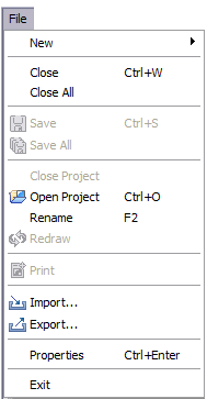
File Menu
The file menu enabled you to create, save, close print import and export resources.

New
Allows you to create new resources.
New Project
Opens the New Project wizard allowing you to create a new project directory for your uDig work.
You can have several projects open at one time.
New Map
Creates a new Map for the current Project.
If there are no projects open a new project will be created as well.
New Layer
Open the Add Data wizard to add a new layer to the current Map.
If there is no Map opened a new Map will be created as needed.
Other
Opens the New Wizard Dialog allowing access to all available New Wizard. Additional wizards may be defined by any community plug-ins you have installed.
Close
Close the current Map Editor or Page Editor.
When a Map editor has unsaved changes you will be asked if you want to save your work before the editor is closed.
This menu is only available when an Editor is already opened.
Close All
Close all maps and pages.
If any editor has unsaved changes you will be asked if you want to save your work.
Save
Save contents of the current Map or Page editor. If the map contains any temporary content the user will be given a chance to save this content rather than lose their work.
This menu is only available when a map is already opened.
Save All
Save all opened Editors.
Close Project
Close a project. This menu is only available when a project is already opened.
Open Project
Opens a file dialog allowing you to select a project to open.
Print
Performs the print actions for the active editor:
- Map editor - will run the Print Wizard allowing you to create a new page
- Page editor - will open a print dialog allowing you to specify a printer
Rename
Rename selected resource. This command can be used to rename Projects, Maps or Layers.
Redraw
Redraw the active Map Editor.
Import
Open the Import Wizard allowing you add additional existing resources into the application.
Export
Open the Export Wizard allowing you to export the selected resource to an external file or service.
Properties
Open the Properties dialog for the selected resource. The Properites dialog can be used to:
- inspect details such as file location or coordinate reference system
- some properties may be modified